Day Two Hundred-thirteen, Date Tuesday, September 29, 2009
Time in Saddle: 6:55
Distance for the Day: 55.30 miles From Howe To Carey, ID
Accumulated Trip Distance: 10,744 miles
Altitudes: Starting/Ending 5427’/4954’, Highest: 6073’ Accumulated: 1588’
Speeds: Avg: 7.9 mph, Max: 31.0 mph
Weather: 59°
Expenditures: $9

I woke up at 7:03am, and got up by 7:06am. It was calm at first, but a few minutes later, a strong wind of 20-25mph came up at 7:15am, making my campsite breakdown challenging. Sunrise came at 7:30am, and the sky was partly cloudy. I was ready to roll by 7:55am into the west with a strong headwind, but by the time I got to Arco at 9:32am, the wind had died down, again. The clouds looked like they could rain, but there are also wide swaths of blue sky, too. When I arrived in Arco, I saw the unlikely sight of a display featuring a torpedo, and a 20’ high conning tower from an actual nuclear submarine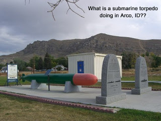 (!) off to the side of the main road. An older gentleman came over to admire my trike while I was taking pictures of the torpedo, and as it turned out, he was the man who not only established the display, but he was a retired nuclear engineer and physicist who helped build the power plants for America’s first nuclear-powered submarines. He and his two daughters also happened to be avid cyclists, which was why he was so interested in my trike (he had been thinking of getting a recumbent, too). There was a tiny, one-room museum a few yards past the torpedo exhibit, and he opened it up and gave me a tour of the place, and talked about nuclear
 submarines, and nuclear power around the US. The room was crammed full of fascinating artifacts and displays, and my ‘tour guide,’ Clay Condit, spoke enthusiastically and knowledgeably about the history and current state of the world’s use of nuclear power in war and in peace. A lot of the research and construction of the nuclear power plants for submarines back in the 50s were done in Arco, hence the museum and exhibit’s location. Meanwhile, Mary, another person involved with the museum, called to have someone from the local newspaper interview me. I told Clay I was going to go find a place to have breakfast, and he recommended The Pickle, a
 restaurant just across the street, and said he would pay for my meal - wow! So, I first went up the street a bit to give my interview to Don Cammack of The Arco Advertiser, and then came back to the restaurant, and had a nice breakfast of eggs, sausage, hash browns, and toast. Thanks, Clay! I stopped at the local grocery store to stock up on drink and food items ($6), and was ready to continue on at 11:28am. The sky had gotten kind of threatening looking, and the wind was medium-annoying, at about 10-15mph, but I still stopped at the Craters of the Moon interpretive center from 3-3:30pm to take just a peek at their exhibits and gift shop. I also got two cans of soda
 ($2) and left a buck for donation, before moving on. The temperature dropped about 10 degs from 75 to 65 and the windchill made things chilly, indeed. By 6:30pm, it still looked like it could rain, when I entered the town of Carey and looked for a stealth camp location. I found a Dept of Transport yard which looked deserted, but shared a driveway with a couple of mobile homes to the right. I went to one of the nearby mobile homes to ask if they thought anyone would mind my camping next to the DOT building (to be out of the wind). I saw a silhouette of someone inside, who moved a little when I waved, but didn’t get up to find out what I wanted (shades of Cross City, Dixie County Florida), so I went back to the DOT building, hung out a bit, and then said, “what the heck,” and set up my tent. I was in it for about a half hour munching and reading my book before headlights hit it, and I could hear a truck drive up and park on the side of the building, around the corner to the side where I was camped. I poked my head out after a little while, and saw the DOT guy, who said this would not be a good place to camp. He said his shift boss would probably call the cops, but that there was a town park and fairground just up the street a quarter mile where I could camp. I thanked him, packed up everything quickly, and went off down the road at 7:30pm to find the park. This was a bigger town than I had first thought, and it did indeed have a small park, and a larger fairgrounds area that was out of view of any houses, and away from the main street by several hundred yards. Excellent! It had gotten dark by now, but I found a small building (N43 18.794’ W113 56.857’) that would block the wind, and set my tent up next to it; I was set up and inside by 8pm. Unfortunately, the building had a door that would bang a few times if the wind got particularly strong, but that didn’t happen very often, so I was able to get a fair night’s sleep despite the wind and faint traffic noise from the main street. I lucked-out, as it started to lightly rain about 15 minutes after I got inside my tent, and I got to sleep, nice and dry, around 8:50pm. This day was always overcast, cool, windy, with a headwind came and went, but I still made fairly good progress, and was now low enough to at least escape the snow.
Time in Saddle: 6:55
Distance for the Day: 55.30 miles From Howe To Carey, ID
Accumulated Trip Distance: 10,744 miles
Altitudes: Starting/Ending 5427’/4954’, Highest: 6073’ Accumulated: 1588’
Speeds: Avg: 7.9 mph, Max: 31.0 mph
Weather: 59°
Expenditures: $9

I woke up at 7:03am, and got up by 7:06am. It was calm at first, but a few minutes later, a strong wind of 20-25mph came up at 7:15am, making my campsite breakdown challenging. Sunrise came at 7:30am, and the sky was partly cloudy. I was ready to roll by 7:55am into the west with a strong headwind, but by the time I got to Arco at 9:32am, the wind had died down, again. The clouds looked like they could rain, but there are also wide swaths of blue sky, too. When I arrived in Arco, I saw the unlikely sight of a display featuring a torpedo, and a 20’ high conning tower from an actual nuclear submarine
 (!) off to the side of the main road. An older gentleman came over to admire my trike while I was taking pictures of the torpedo, and as it turned out, he was the man who not only established the display, but he was a retired nuclear engineer and physicist who helped build the power plants for America’s first nuclear-powered submarines. He and his two daughters also happened to be avid cyclists, which was why he was so interested in my trike (he had been thinking of getting a recumbent, too). There was a tiny, one-room museum a few yards past the torpedo exhibit, and he opened it up and gave me a tour of the place, and talked about nuclear
 submarines, and nuclear power around the US. The room was crammed full of fascinating artifacts and displays, and my ‘tour guide,’ Clay Condit, spoke enthusiastically and knowledgeably about the history and current state of the world’s use of nuclear power in war and in peace. A lot of the research and construction of the nuclear power plants for submarines back in the 50s were done in Arco, hence the museum and exhibit’s location. Meanwhile, Mary, another person involved with the museum, called to have someone from the local newspaper interview me. I told Clay I was going to go find a place to have breakfast, and he recommended The Pickle, a
 restaurant just across the street, and said he would pay for my meal - wow! So, I first went up the street a bit to give my interview to Don Cammack of The Arco Advertiser, and then came back to the restaurant, and had a nice breakfast of eggs, sausage, hash browns, and toast. Thanks, Clay! I stopped at the local grocery store to stock up on drink and food items ($6), and was ready to continue on at 11:28am. The sky had gotten kind of threatening looking, and the wind was medium-annoying, at about 10-15mph, but I still stopped at the Craters of the Moon interpretive center from 3-3:30pm to take just a peek at their exhibits and gift shop. I also got two cans of soda
 ($2) and left a buck for donation, before moving on. The temperature dropped about 10 degs from 75 to 65 and the windchill made things chilly, indeed. By 6:30pm, it still looked like it could rain, when I entered the town of Carey and looked for a stealth camp location. I found a Dept of Transport yard which looked deserted, but shared a driveway with a couple of mobile homes to the right. I went to one of the nearby mobile homes to ask if they thought anyone would mind my camping next to the DOT building (to be out of the wind). I saw a silhouette of someone inside, who moved a little when I waved, but didn’t get up to find out what I wanted (shades of Cross City, Dixie County Florida), so I went back to the DOT building, hung out a bit, and then said, “what the heck,” and set up my tent. I was in it for about a half hour munching and reading my book before headlights hit it, and I could hear a truck drive up and park on the side of the building, around the corner to the side where I was camped. I poked my head out after a little while, and saw the DOT guy, who said this would not be a good place to camp. He said his shift boss would probably call the cops, but that there was a town park and fairground just up the street a quarter mile where I could camp. I thanked him, packed up everything quickly, and went off down the road at 7:30pm to find the park. This was a bigger town than I had first thought, and it did indeed have a small park, and a larger fairgrounds area that was out of view of any houses, and away from the main street by several hundred yards. Excellent! It had gotten dark by now, but I found a small building (N43 18.794’ W113 56.857’) that would block the wind, and set my tent up next to it; I was set up and inside by 8pm. Unfortunately, the building had a door that would bang a few times if the wind got particularly strong, but that didn’t happen very often, so I was able to get a fair night’s sleep despite the wind and faint traffic noise from the main street. I lucked-out, as it started to lightly rain about 15 minutes after I got inside my tent, and I got to sleep, nice and dry, around 8:50pm. This day was always overcast, cool, windy, with a headwind came and went, but I still made fairly good progress, and was now low enough to at least escape the snow.
2 comments:
Arco, Idaho! Yeah, one of my and Kevin's favorite places. Surprised you didn't mention the "Hill" where all of the high school's classes for the last, oh, 75 years, have climbed up that rock cliff and painted their class number somewhere. We spent an hour one time just trying to find all of the years in order! Climbed through the original nuclear reactor there, too. (decommissioned, of course). I think we've even eaten at The Pickle, too.
Great trip. I know it's getting cold, but hang in there. What's your route through WA and Oregon?
Denni Medlock
Hi Denni: Oh! So *that's* what all those spray painted numbers were. I thought it was just graffiti or some geologists surveying the geography. Interesting... My route from here will roughly be: up through western Idaho into Oregon via Hwy 94, then the NW peninsula of Washington, then south along the Pacific Coast, back to SF. Yeeehawwww! ;~Don
Post a Comment