Monday, August 10, 2009
Quick Update, Monday, Aug 10, 2009
Hi all: Just wanted to give you a quick update. I am currently in a Denny's with wi-fi in Rome, NY, and continuing to head west toward Niagara Falls. I'll pass through Rochester by the 12th, where my newphew and his fiancee live, and do full updates then. It's a rain day, today (ugh!), but I can't let a little water stop me! (Can I?) I'm pretty much guaranteed to get soaked, but I've got my waterproof socks on (Subway sandwich bags), so at least my feet will be comfortable, I hope. Thanks for your continued interest and support! ;~Don

Tuesday, August 4, 2009
Day One Hundred Fifty-five, 090802 - N. Turner, ME
Day One Hundred Fifty-five, Date Sunday, August 2, 2009
Time in Saddle: 8:58
Distance for the Day: 77.14 miles From Searsport, ME To North Turner, ME
Accumulated Trip Distance: 7332.45 miles
Altitudes: Starting/Ending 40’/510’, Highest: 682’ Accumulated: 4701’
Speeds: Avg: 8.6 mph, Max: 40.3 mph
Weather: 61° mostly cloudy all day turning to rain by midnight
Expenditures: $15
Time in Saddle: 8:58
Distance for the Day: 77.14 miles From Searsport, ME To North Turner, ME
Accumulated Trip Distance: 7332.45 miles
Altitudes: Starting/Ending 40’/510’, Highest: 682’ Accumulated: 4701’
Speeds: Avg: 8.6 mph, Max: 40.3 mph
Weather: 61° mostly cloudy all day turning to rain by midnight
Expenditures: $15

I woke up at about 5:15am and got up at 5:30am, then broke down and was ready to roll by 6:15am. I stopped at Dunkin Donuts from 7:30am – 8:40am to charge up notebook, do some blog writeups, and get a bagel w/cream cheese, donut, and hot cocoa ($5). Not much of interest happened, today – it was just a travel day. At 11am I stopped for drinks and food ($4), and continued west on Rt 3. I stopped a few more times during the day for drinks and food ($10). At 3:30pm I had dinner at Burger King ($6), and charged up my notebook. Continuing west on Rt 202. I did notice, every now and then, during the course of this trip, young males would shout something at me unintelligibly from their cars or trucks. This morning, one cried out, “Sweet ride, homo!” I ignored him. Today, I got *three* shouts from young males in trucks. Coincidence? Or is this a Maine thing? Oh, here’s another trip tip: the crotch cloth. I found that I could stuff small hand towels around my private parts, and this would keep my underwear clean for a much longer time. I could then wash the hand towels and re-use them over and over. Saves a bit of space trying to stock lots of fresh underwear, not to mention the problem of trying to find someplace to get naked enough to change underwear. The weather became overcast and drizzly the last hour of the evening. I was riding through hilly, private residential landscape, and not much in the way of decent stealth camps, when I finally came to a firehouse next to a baseball field. There was some kind of meeting being held, as there were cars parked in front of the firehouse. I got permission to set up my tent next to the firehouse and field (N44 20.476’ W70 14.891’), and by 8:12pm I was all set up and inside my tent
 with munchies, drink and book, which I finished (Ayn Rand’s “Atlas Shrugged”). I was mostly dry, warm, and had a nice sleep. I did get awaked at 11:30pm when it rained hard late in the evening, but then stopped after about a half-hour or an hour. As usual, the tent worked like a charm.

 course of this trip, young males would shout something at me unintelligibly from their cars or trucks. This morning, one cried out, “Sweet ride, homo!” I ignored him. Today, I got *three* shouts from young males in trucks. Coincidence? Or is this a Maine thing? Oh, here’s another trip tip: the crotch cloth. I found that I could stuff small hand towels around my private parts, and this would keep my underwear clean for a much longer time. I could then wash the hand towels and re-use them over and over. Saves a bit of space trying to stock lots of fresh underwear, not to mention the problem of trying to find someplace to get naked enough to change underwear. The weather became overcast and drizzly the last hour of the evening. I was riding through hilly, private residential landscape, and not much in the way of decent stealth camps, when I finally came to a firehouse next to a baseball field. There was some kind of meeting being held, as there were cars parked in front of the firehouse. I got permission to set up my tent next to the firehouse and field (N44 20.476’ W70 14.891’), and by 8:12pm I was all set up and inside my tent
 with munchies, drink and book, which I finished (Ayn Rand’s “Atlas Shrugged”). I was mostly dry, warm, and had a nice sleep. I did get awaked at 11:30pm when it rained hard late in the evening, but then stopped after about a half-hour or an hour. As usual, the tent worked like a charm.


Day One Hundred Fifty-four, 090801 - Searsport, ME
Day One Hundred Fifty-four, Date Saturday, August 1, 2009
Time in Saddle: 10:02
Distance for the Day: 91.6 miles From Jonesboro, ME To Searsport, ME
Accumulated Trip Distance: 7255.31 miles
Altitudes: Starting/Ending 104’/40’, Highest: 430’ Accumulated: 4088’
Speeds: Avg: 9.1 mph, Max: 37.2 mph
Weather: 60° mostly cloudy, but broken and clearing
Expenditures: $20
Time in Saddle: 10:02
Distance for the Day: 91.6 miles From Jonesboro, ME To Searsport, ME
Accumulated Trip Distance: 7255.31 miles
Altitudes: Starting/Ending 104’/40’, Highest: 430’ Accumulated: 4088’
Speeds: Avg: 9.1 mph, Max: 37.2 mph
Weather: 60° mostly cloudy, but broken and clearing
Expenditures: $20
 Woke up 4:30am, got up at 5am, and was ready to go by 5:57am. One note from yesterday: my waterproof jacket was not designed for trike riding. In my reclined position, and the usual tilt to the right on the right side of roads, rainwater would gather on my chest and stomach, and “drain” under the zipper flap, into the zipper, and onto my shirt, underneath. It still keeps me warm, but my upper body got soaked. The new waterproof pants worked great, as long as I didn’t work too hard and get soaked by my own sweat. However, the two side panniers for my sleeping bag and tent/hammock definitely leak, and water gather
 s at the bottom of them, soaking my hammock and one end of my sleeping bag. I think water splashes up under the zipper’s flap. I don’t know if there’s anything I can do about that. I stopped for a mini mart breakfast of choco Muscle Milk (ugh!) and Danish ($5) at 7am, and stopped for grapefruit juice at 9:17 ($2) before continuing south on Hwy 1. I got drinks and food at a couple of stops during the day ($13). My trike’s gearing was still messed-up, and I still don’t know how to fix it, but I’m learning to live with it. I’ll have to get them fixed by a bike mechanic in the not-too-distant future. I stopped in an empty spot beside a for-sale business building to dry out my
  sleeping bag, hammock, ropes, and hat on the pavement. The weather turned beautiful, so everything dried pretty quick, while I ate the other half of my Subway sandwich for lunch from 12pm – 12:53pm. Near the end of the day, I made my stealth camp at a park with water views and that had open bathroom facilities (N44° 27.341', W68° 55.454'). It was officially closed, but I was able to roll in under the gate after taking my flag off easily enough. I used the bathroom facility to take sponge bath, wash hair, and change clothes. I hung my hammock in the dark, between trees, and called Auntie M at 9:15pm (6:15pm her time). There was only a distant, barely
 heard ‘swish’ of traffic noise; it was otherwise almost totally silent. I could see the lights of a small coastal town to the north, and tall trees towering above me through the mosquito netting of my hammock.
Day One Hundred Fifty-three, 090731 - Jonesboro, ME
Day One Hundred Fifty-three, Date Friday, July 31, 2009
Time in Saddle: 4:57
Distance for the Day: 44.28 miles From Quoddy Head To Jonesboro, ME
Accumulated Trip Distance: 7163.71 miles
Altitudes: Starting/Ending 50’/104’, Highest: 226’ Accumulated: 2418’
Speeds: Avg: 8.9 mph, Max: 37.5 mph
Weather: 55° partly cloudy
Expenditures: $16
Time in Saddle: 4:57
Distance for the Day: 44.28 miles From Quoddy Head To Jonesboro, ME
Accumulated Trip Distance: 7163.71 miles
Altitudes: Starting/Ending 50’/104’, Highest: 226’ Accumulated: 2418’
Speeds: Avg: 8.9 mph, Max: 37.5 mph
Weather: 55° partly cloudy
Expenditures: $16
 I woke up at 5:22am, and quickly got my shoes on, grabbed my camera, and hurried down to the lighthouse. I was just in time to see the first sunrise in America on the last day of July, 2009! That was the whole reason I pushed so hard yesterday; for this chance to see something so unique – well, for this west coast California boy, at least. No one else was there, so out of the 300+million people in America, I was the only one who caught this particular day’s first sunrise. Sometimes, I amaze even my self. I took lots of pictures of this gorgeous spectacle, and then had a bit of breakfast (banana, grapefruit juice, breakfast bar, and M&Ms (peanut). Then, I found an external power outlet at the visitor center, and plugged in to recharge the ol’ laptop and camera battery, and to do some blog writeups while waiting for the visitor center to open at 10am. At 8am, the managing park ranger came out (he lives here), and we chatted a bit before he took off for town. I asked him if the sound of the horn bothered him, and he said he didn’t even hear it, anymore. Amazing! He told me about a road back to Rte 191
 that followed the coast from Quoddy Head that was better than the totally cruddy road going through Lubec that wasn’t even on my Street Atlas computer map. It went through a couple of towns with funny sounding names, like “Jacob’s Mistake,” or “Durham’s Disaster,” (not actual names – I can’t remember the real ones, but something like that). They were the places ships had wrecked on the coast. The places were named after the captains who wrecked their ships, and rather than face the consequences with the ships’ owners, they settled there, instead. I went into the visitor center at 10am and chatted with the lady there, looked at the exhibits and the art gallery (nice stuff!) I didn’t see any puffins (sorry Julie), but the lady said this wasn’t the time of year to see them, that there were cruises in towns nearby to see them when they *are* here, and that there is also a “puffin cam” on the web, that puts out a live feed – so you can see them doing that. I left a donation in the available tin ($5), and then took off at about 10:45am for the next leg of my trip: west! I decided not to use the route John S suggested, as I wasn’t
 sure where it started, and he said a section of it wasn’t paved, and I thought I might have a hard time navigating it. This time, I followed my route carefully, and successfully found and rode Rte 191 south (the one I missed coming north) along the Maine coast. It was indeed a very nice ride, but there were no services along its entire length (well, from Quoddy to Machias), so I had a lunch of trailmix and a meat/cheese stick with Gatorade (yum!) There was very little traffic, tree-lined, very pretty, and it went through a few scenic coastal sites, which I stopped and took pictures of, every now and then. The weather was mostly clear, with warm sunshine, but cool
 air temperatures – perfect for cycling, though there were no services (almost ran out of Gatorade!). By the time I reached Hwy 1 again, though, the sky clouded up and by 3pm, it started to sprinkle, and then rain (boo-hoo!) I stopped at the mini mart to replenish my liquids ($3), and then went into Machias to get a Subway meal deal ($8), recharge the notebook, and wait for the rain to hopefully let up a little – it didn’t. I took off again at 5:15pm, with my feet in plastic bags. By the way: I asked the countergirl at Subway for a couple of extra bags, and used them for my feet. Subway sandwich bags make *excellent* waterproof footbags! One more trip tip for ya! Route 1 south of Machias is really terrible; not only is there no shoulder, the edge of the road is broken and rough. That plus the rain in the onset of evening was not pleasant. It was still a bit early, about 6:30pm, but I saw a big, mostly empty lot with a couple of office buildings, a few pieces of heavy earth moving equipment, and a very large Quonset-hut like building with its big roll-up door open (N44 39.949’ W67 33.648’). I pulled off the highway, passed by the dark office buildings, and rolled right into that big Quonset hut “barn.” The rain hitting the metal roof of that giant building made a terrific roar, but it was clean and dry, and about 1/3 full of *salt.* Mountains of salt, presumably for de-icing roads. The asphalt ground of this place looked like it might be oily, and I didn’t want to set up my tent on an oily floor. However, I did find a small patch of clean concrete in a front corner of the building, just right to set my tent up on – how nice! There were no mosquitoes, so I leisurely set up, put some things out to dry, got my book and a bit of food and drink, and hopped in at about 7:30pm for a good read. The rain stopped at about 8:30pm, so the roaring white noise went away, and everything was quiet. I had a very nice dry, quiet sleep,
Day One Hundred Fifty-two, 090730 - Quoddy Head, ME
Day One Hundred Fifty-two, Date Thursday, July 30, 2009
Time in Saddle: 10:06
Distance for the Day: 95.7 miles From Millbridge To Quoddy Head, ME
Accumulated Trip Distance: 7119.43 miles
Altitudes: Starting/Ending 50’/50’, Highest: 567’ Accumulated: 4757’
Speeds: Avg: 9.4 mph, Max: 39.2 mph
Weather: 60° a little breezy and foggy w/light rain thru noon, breaking up by mid-afternoon to partly cloudy and then mostly clear
Expenditures: $16

Time in Saddle: 10:06
Distance for the Day: 95.7 miles From Millbridge To Quoddy Head, ME
Accumulated Trip Distance: 7119.43 miles
Altitudes: Starting/Ending 50’/50’, Highest: 567’ Accumulated: 4757’
Speeds: Avg: 9.4 mph, Max: 39.2 mph
Weather: 60° a little breezy and foggy w/light rain thru noon, breaking up by mid-afternoon to partly cloudy and then mostly clear
Expenditures: $16

I got up at 5am and broke down and was ready to roll by 5:56am. It was foggy enough that I ran with my lights for a while, until the day brightened up some more. I got a couple more mosquito bites on my hand before making my escape from this site. I made Machias by 9:45am and spent about 40 mins at an internet espresso place to get a hot cocoa, blueberry scone, and to get online to pay my June credit card bill. At 10:32am, I took off to continue my way to Quoddy Head, a good 36 miles to go (I thought – hah!) After a couple of missed turns and many extra “zig-zag” course miles, it got to be 5pm and still had a ways to go before reaching Quoddy Head. I thought I might or might not make it, today. I got drink and food items ($10) at a couple of stops along the way, and then had a very serious mechanical problem. I’d been having trouble getting the range of gears to shift properly, without slipping or chattering – none of my usual cable length adjustments seemed to work. After my last adjustment, I inadvertently set my lowest gear setting to go *past* the actual lowest gear. The only thing past the lowest gear was the space between the lowest gear and the wheel’s hub. I hit a particularly steep hill, shifted to my lowest gear, and promptly got my chain stuck between the gear cassette and the hub. I rolled my trike into a level spot on a nearby driveway, and began to try to unstuck the chain. Nothing I could do worked. Uh-oh. A guy drove into the driveway and unloaded his truck at the house, then came back up to see what I was up to. He and I looked at the problem, and figured a long screwdriver might be able to be used to tap the stuck chain links out of the gap. Peter F (that’s his name) said he’d get one, and drove off, then came back a few minutes later with the 20” long screwdriver and a couple of hammers. Using these tools, I was able to get the chain unstuck. Great! I thanked him, hopped on my trike, put it in low gear, and promptly got the chain stuck, again. Peter stopped by again, and let me use his screwdriver and hammer again. This time, he gave me that screwdriver! It was his grandfather’s, and his father’s screwdriver, and the
 wooden handle was partially broken, and it was rusty, and Peter didn’t really need it anymore, so he gave it to me. Thanks! This time, I stayed in gear, and made my way to the top of the hill. Peter watched me until I was out of sight, before taking off, himself. His wife was with him, too, and she was very patient about the whole thing. Nice folks, to be sure. On level ground, I figured out what was wrong, adjusted it as best I could, but I think something got actually damaged, because now several of the gears were acting *really* bad. Not know what else to do, I just grinned and bared it. I still had the use of enough gears to handle all conditions, they just weren’t smooth and trouble free like before. The weather had cleared up by mid-afternoon, and so I was now *determined* to get to Quoddy Head, tonight, to have the chance to see the first sunrise in America tomorrow morning. With aching knees, roads with broken pavement and no shoulders, and a sudden drop in temperature (from the mid-60s to the mid 50s) I layered up with jacket and rain coat and pants, thermal gloves and
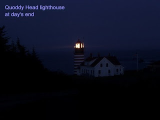
 pushed on. I made the town of Lubec a bit before sunset. Lubec has some of the worst roads I have ever seen in this whole trip. Warped, broken, and roughly patched, I’ve been on gravel roads that were nicer than this. I stopped to get a sandwich and drinks at the mini mart gas station in town ($6) (I burned more calories than usual to get here) and continued on the last 7 mile leg to my goal. When I turned off the main road to head to the state park, the road became nice, again (whew!) Still no shoulder, but at least I could go as fast as possible and not get my teeth jarred out of my head. By the time I finally arrived at the lighthouse, the last bit of blue was in the sky before the black of night. The stars, which I hadn’t seen in quite a while, were starting to come out; I could see the bright stars of the summer triangle, and the now waxing gibbous moon came shining through the pine forest. I could hear the fog horn in the darkness, and as I turned the last corner, I caught my first sight of the lighthouse beacon at the end of my very long road. I parked my trike in the parking lot and took some long exposure
 photos of the lighthouse. I heard someone walk across the gravel a couple dozen yards away, but couldn’t quite make him out in the dark. A few minutes later he started up his truck, and drove up to me to ask what I was up to. I asked if he worked here, and he said he did. I asked if it would be okay, despite the “no camping” sign, if I set up my tent in some out of the way corner somewhere, and he said he’d seen me in Ellsworth (about 90 miles away), and that I could set up over by a small work building off to the side – cool! I kind of lucked-out on that. So, I set up my tent next to a boat on a level bit of gravel (N44 48.962’ W66 57.102’), brought in a bag of
 trail mix and a bottle of Gatorade, and munched and read my book by penlight until 11pm. Getting to sleep with the sound of the fog horn and the low roar of the surf challenged me all of a half-hour before I fell asleep.
 to go *past* the actual lowest gear. The only thing past the lowest gear was the space between the lowest gear and the wheel’s hub. I hit a particularly steep hill, shifted to my lowest gear, and promptly got my chain stuck between the gear cassette and the hub. I rolled my trike into a level spot on a nearby driveway, and began to try to unstuck the chain. Nothing I could do worked. Uh-oh. A guy drove into the driveway and unloaded his truck at the house, then came back up to see what I was up to. He and I looked at the problem, and figured a long screwdriver might be able to be used to tap the stuck chain links out of the gap. Peter F (that’s his name) said he’d get one, and drove off, then came back a few minutes later with the 20” long screwdriver and a couple of hammers. Using these tools, I was able to get the chain unstuck. Great! I thanked him, hopped on my trike, put it in low gear, and promptly got the chain stuck, again. Peter stopped by again, and let me use his screwdriver and hammer again. This time, he gave me that screwdriver! It was his grandfather’s, and his father’s screwdriver, and the
 wooden handle was partially broken, and it was rusty, and Peter didn’t really need it anymore, so he gave it to me. Thanks! This time, I stayed in gear, and made my way to the top of the hill. Peter watched me until I was out of sight, before taking off, himself. His wife was with him, too, and she was very patient about the whole thing. Nice folks, to be sure. On level ground, I figured out what was wrong, adjusted it as best I could, but I think something got actually damaged, because now several of the gears were acting *really* bad. Not know what else to do, I just grinned and bared it. I still had the use of enough gears to handle all conditions, they just weren’t smooth and trouble free like before. The weather had cleared up by mid-afternoon, and so I was now *determined* to get to Quoddy Head, tonight, to have the chance to see the first sunrise in America tomorrow morning. With aching knees, roads with broken pavement and no shoulders, and a sudden drop in temperature (from the mid-60s to the mid 50s) I layered up with jacket and rain coat and pants, thermal gloves and
 pushed on. I made the town of Lubec a bit before sunset. Lubec has some of the worst roads I have ever seen in this whole trip. Warped, broken, and roughly patched, I’ve been on gravel roads that were nicer than this. I stopped to get a sandwich and drinks at the mini mart gas station in town ($6) (I burned more calories than usual to get here) and continued on the last 7 mile leg to my goal. When I turned off the main road to head to the state park, the road became nice, again (whew!) Still no shoulder, but at least I could go as fast as possible and not get my teeth jarred out of my head. By the time I finally arrived at the lighthouse, the last bit of blue was in the sky before the black of night. The stars, which I hadn’t seen in quite a while, were starting to come out; I could see the bright stars of the summer triangle, and the now waxing gibbous moon came shining through the pine forest. I could hear the fog horn in the darkness, and as I turned the last corner, I caught my first sight of the lighthouse beacon at the end of my very long road. I parked my trike in the parking lot and took some long exposure
 photos of the lighthouse. I heard someone walk across the gravel a couple dozen yards away, but couldn’t quite make him out in the dark. A few minutes later he started up his truck, and drove up to me to ask what I was up to. I asked if he worked here, and he said he did. I asked if it would be okay, despite the “no camping” sign, if I set up my tent in some out of the way corner somewhere, and he said he’d seen me in Ellsworth (about 90 miles away), and that I could set up over by a small work building off to the side – cool! I kind of lucked-out on that. So, I set up my tent next to a boat on a level bit of gravel (N44 48.962’ W66 57.102’), brought in a bag of
 trail mix and a bottle of Gatorade, and munched and read my book by penlight until 11pm. Getting to sleep with the sound of the fog horn and the low roar of the surf challenged me all of a half-hour before I fell asleep.
 Day One Hundred Fifty-one, 090729 - Millbridge, ME
Day One Hundred Fifty-one, Date Wednesday, July 29, 2009
Time in Saddle: 7:23
Distance for the Day: 69.29 miles From Belfast To Millbridge, ME
Accumulated Trip Distance: 7023.73
Altitudes: Starting/Ending 99’/50’, Highest: 441’ Accumulated: 3386’
Speeds: Avg: 9.3 mph, Max: 34.0 mph
Weather: 60°
Expenditures: $83 (yipes!)
Time in Saddle: 7:23
Distance for the Day: 69.29 miles From Belfast To Millbridge, ME
Accumulated Trip Distance: 7023.73
Altitudes: Starting/Ending 99’/50’, Highest: 441’ Accumulated: 3386’
Speeds: Avg: 9.3 mph, Max: 34.0 mph
Weather: 60°
Expenditures: $83 (yipes!)

Woke up at 5am. It was foggy, but I saw some blueness straight up, so that was hopeful. I packed up and was ready to go by 5:45am. I stopped at mini mart in Bucksport and got some food items and drink ($5) at 9:27am. A little while later and up the road, I went over the amazing, very modernly designed Penobscot Bridge. I took several pictures of it despite all the fog, and continued north on Hwy 1. By 9:52am, the fog started to break up, but there was an upper cumulo-stratus layer still blocking the sun, but I could begin to feel the infra-red heat through the clouds, anyways. I stopped at the Dunkkin Donuts in Searsport to charge up my notebook, and, since I was there, *anyways,* also got a donut, bagel w/cream cheese and hot cocoa ($5), too. At noon, I stopped in Ellsworth, ME, and went into the Cadillac Mtn Sports shop to check for reflective triangles (didn’t have them – no surprise – no one does, anymore), but picked up two pairs of expensive, high-tech cycling underwear ($48) (hey – I’m worth it. I probably shouldn’t say this, but my ass crack is getting *callused* - can you believe it?!) I then went to Subway a few doors down the road for a meal deal ($9) and to read my book (getting close to finishing it). I then decided to check to see if the
 Denny’s next to Subway had free wi-fi, and surprise - they did. So, I stopped at Denny’s for dessert and free wi-fi ($7) (not necessarily in that order), and finished uploading my two last blog entries with pictures. I took off at 2:15pm. The weather was warm and humid, but I could see the clouds off in the east that were probably going to rain on me. Bummer. Nothing for it but to continue on, rain and lightning or no rain and lightning. By 3:22pm the weather did indeed looked like it was getting ready to rain. I went to a Lowe’s for Shoe Goo ($3) and a Wal-mart for trail mix and a sewing kit ($6), so now I had everything I needed to repair my tent.
 Continuing north on Hwy 1, at 4:59pm I found a wallet (N44 30.697’ W68 10.281’) with no money or credit cards or anything, but some stuff in it identifying Heidi Bauer as the owner. I gathered up some of the contents that were scattered around the immediate area, and turned the wallet over to a policeman who I met at a mini mart a few miles up the road who said he’d get it to her. I got some drinks at 5:37pm at that mini mart ($3). I discovered I’d kind of gotten off my route – not too bad, but I was following the coast more, so it took a little longer to make actual forward progress. I found a marginal stealth camp at about 7:30pm behind a utility building off the road. In order to stay out of view of traffic, I had to set up on dirt/gravel area (N44 33.154’ W67 53.034’). There were a lot of mosquitoes, and a couple of ‘em got me. I covered up with rain gear and head net while I set up, and used the Avon Skin So Soft to keep ‘em off my exposed hands. That stuff really does work! Due to the clouds, it was prematurely dark, so I had to use my penlight to read my book after going to bed at 8pm. A brief
 thunderstorm passed over, but it didn’t go right overhead, so it rained a bit, with no close lightning strikes.
 Dunkkin Donuts in Searsport to charge up my notebook, and, since I was there, *anyways,* also got a donut, bagel w/cream cheese and hot cocoa ($5), too. At noon, I stopped in Ellsworth, ME, and went into the Cadillac Mtn Sports shop to check for reflective triangles (didn’t have them – no surprise – no one does, anymore), but picked up two pairs of expensive, high-tech cycling underwear ($48) (hey – I’m worth it. I probably shouldn’t say this, but my ass crack is getting *callused* - can you believe it?!) I then went to Subway a few doors down the road for a meal deal ($9) and to read my book (getting close to finishing it). I then decided to check to see if the
 Denny’s next to Subway had free wi-fi, and surprise - they did. So, I stopped at Denny’s for dessert and free wi-fi ($7) (not necessarily in that order), and finished uploading my two last blog entries with pictures. I took off at 2:15pm. The weather was warm and humid, but I could see the clouds off in the east that were probably going to rain on me. Bummer. Nothing for it but to continue on, rain and lightning or no rain and lightning. By 3:22pm the weather did indeed looked like it was getting ready to rain. I went to a Lowe’s for Shoe Goo ($3) and a Wal-mart for trail mix and a sewing kit ($6), so now I had everything I needed to repair my tent.
 Continuing north on Hwy 1, at 4:59pm I found a wallet (N44 30.697’ W68 10.281’) with no money or credit cards or anything, but some stuff in it identifying Heidi Bauer as the owner. I gathered up some of the contents that were scattered around the immediate area, and turned the wallet over to a policeman who I met at a mini mart a few miles up the road who said he’d get it to her. I got some drinks at 5:37pm at that mini mart ($3). I discovered I’d kind of gotten off my route – not too bad, but I was following the coast more, so it took a little longer to make actual forward progress. I found a marginal stealth camp at about 7:30pm behind a utility building off the road. In order to stay out of view of traffic, I had to set up on dirt/gravel area (N44 33.154’ W67 53.034’). There were a lot of mosquitoes, and a couple of ‘em got me. I covered up with rain gear and head net while I set up, and used the Avon Skin So Soft to keep ‘em off my exposed hands. That stuff really does work! Due to the clouds, it was prematurely dark, so I had to use my penlight to read my book after going to bed at 8pm. A brief
 thunderstorm passed over, but it didn’t go right overhead, so it rained a bit, with no close lightning strikes.
Day One Hundred Fifty, 090728 - Belfast, ME
Day One Hundred Fifty, Date Tuesday, July 28, 2009
Time in Saddle: 3:24
Distance for the Day: 27.93 miles From Union, ME To Belfast, ME
Accumulated Trip Distance: 6954.44 miles
Altitudes: Starting/Ending 212’/99’, Highest: 631’ Accumulated: 1923’
Speeds: Avg: 8.2 mph, Max: 38.8 mph
Weather: 65° foggy, clearing by late morning to sunny and warm
Expenditures: $13
 I woke up at 5am with the bright fog of morning putting moisture on everything. This did not deter the mosquitoes, however, so I quickly donned my rain clothes to try and thwart them. I spent an hour packing up my gear, making extra effort to try to do it as clean and dry as possible. I was ready to go at 5:59am, but didn’t see any sign of Cory, so I just took off, heading north from Union. At 6:40am had breakfast at a very mini mart of choco milk and Danish ($2). At another mini mart, at 8:28am I re-supplied drinks ($5). There was a short, torturous bit of a hill climb, still in the fog, where the mosquitoes were crazy numerous; I must have killed more than a d
 ozen of ‘em as they landed on my thigh. I got little “preliminary” probes from them, but managed to kill or swat them away before they began tanking up. The fog lifted around 9am, and I was treated to views of backlit, bejeweled spider webs amongst the flower stalks on the side of the road. I made Belfast by about 10:30am and wandered around a bit in this scenic/quaint/touristy little seaside town before finding a library with free, unlimited wi-fi. So, I then spent the rest of the day, from 10:45am – 6pm blogging. I managed to get 3 or 4 posted out of the 5 or 6 that were now ready, before they closed. I went to the outskirts of town to get dinner at Wendy’s ($6),
 and at 7:06pm, began looking for some stealth camping. Before leaving Wendy’s, I met a fellow who was a member of the Maine Cycling Assoc (or something like that) and he recommended not taking Rte 1 to get to Quoddy Head, but instead using the coast-hugging Rte 191 as it was a better road with less traffic. I also fielded the usual questions from several other people who were admiring my trike. The weather was sunny and warm, but the forecast said “chance of thunderstorms next several days,” so I girded the ol’ loins for yet more wet weather. I didn’t get too much further after leaving Wendy’s, when I found a nice, large visitor center at 8pm that was
 closed for the night (N44 25.683’ W68 58.847’). It had a lower parking lot, so I went down there and set my tent up just under the building’s pilings. The half-moon was out over the trees, and I had a nice view of Penobscot Bay from there. I had a minor disaster with the tent – hooking its material to the tent poles has always been a little difficult because it was so tight. This time, one of the seams ripped about an inch or so, and left a small hole. I tried to start to fix it, but I couldn’t get the dental floss I wanted to use as thread into the eye of the needle. I like using floss as I think it’s better than cotton thread. I’ll have to see if I can buy one of those needle threader thingies, and some Shoe Goo. I was set up by 8:30pm, so I hopped inside and read my book until 9:30pm before falling asleep. It was a nice quiet site with a beautiful view, protected from the noise of the road without being very far from it. Sites just don’t get no better’n this!
Time in Saddle: 3:24
Distance for the Day: 27.93 miles From Union, ME To Belfast, ME
Accumulated Trip Distance: 6954.44 miles
Altitudes: Starting/Ending 212’/99’, Highest: 631’ Accumulated: 1923’
Speeds: Avg: 8.2 mph, Max: 38.8 mph
Weather: 65° foggy, clearing by late morning to sunny and warm
Expenditures: $13
 I woke up at 5am with the bright fog of morning putting moisture on everything. This did not deter the mosquitoes, however, so I quickly donned my rain clothes to try and thwart them. I spent an hour packing up my gear, making extra effort to try to do it as clean and dry as possible. I was ready to go at 5:59am, but didn’t see any sign of Cory, so I just took off, heading north from Union. At 6:40am had breakfast at a very mini mart of choco milk and Danish ($2). At another mini mart, at 8:28am I re-supplied drinks ($5). There was a short, torturous bit of a hill climb, still in the fog, where the mosquitoes were crazy numerous; I must have killed more than a d
 ozen of ‘em as they landed on my thigh. I got little “preliminary” probes from them, but managed to kill or swat them away before they began tanking up. The fog lifted around 9am, and I was treated to views of backlit, bejeweled spider webs amongst the flower stalks on the side of the road. I made Belfast by about 10:30am and wandered around a bit in this scenic/quaint/touristy little seaside town before finding a library with free, unlimited wi-fi. So, I then spent the rest of the day, from 10:45am – 6pm blogging. I managed to get 3 or 4 posted out of the 5 or 6 that were now ready, before they closed. I went to the outskirts of town to get dinner at Wendy’s ($6),
 and at 7:06pm, began looking for some stealth camping. Before leaving Wendy’s, I met a fellow who was a member of the Maine Cycling Assoc (or something like that) and he recommended not taking Rte 1 to get to Quoddy Head, but instead using the coast-hugging Rte 191 as it was a better road with less traffic. I also fielded the usual questions from several other people who were admiring my trike. The weather was sunny and warm, but the forecast said “chance of thunderstorms next several days,” so I girded the ol’ loins for yet more wet weather. I didn’t get too much further after leaving Wendy’s, when I found a nice, large visitor center at 8pm that was
 closed for the night (N44 25.683’ W68 58.847’). It had a lower parking lot, so I went down there and set my tent up just under the building’s pilings. The half-moon was out over the trees, and I had a nice view of Penobscot Bay from there. I had a minor disaster with the tent – hooking its material to the tent poles has always been a little difficult because it was so tight. This time, one of the seams ripped about an inch or so, and left a small hole. I tried to start to fix it, but I couldn’t get the dental floss I wanted to use as thread into the eye of the needle. I like using floss as I think it’s better than cotton thread. I’ll have to see if I can buy one of those needle threader thingies, and some Shoe Goo. I was set up by 8:30pm, so I hopped inside and read my book until 9:30pm before falling asleep. It was a nice quiet site with a beautiful view, protected from the noise of the road without being very far from it. Sites just don’t get no better’n this!
Subscribe to:
Posts (Atom)